
Willamette Mission State Park
4.6Google rating(945 reviews)Salem · park · 1,329 acres
Camping openOpen for camping May 15 – Sep 30




Visit
Best for
Essentials
At a glance
- Hours
Open for day use year round · Open for camping May 15 – Sep 30
On site
Visitor amenities
…stay a while
- Restroomfacility
- Picnic Areafacility
- Parkingfacility
- Accessible Featuresfacility
…get active
- Disc Golfsports
…be in nature
- Wildlife Viewingnature
- Horse Trailsnature
- Bike Pathnature
- Hiking Trailsnature
…near water
- Boat Launchwater
- Fishingwater
- Watercraftwater
…stay overnight
- Campingcamping
…culture & learning
- Interpretiveculture
Access
Accessibility
- Wheelchair accessible
- Accessible parking
- Accessible restroom
- Accessible trail
- Accessible entrance
Inferred from amenities/description; confirm on official sources.
Browse wheelchair-accessible parksPark size map
Official park boundary from GIS.
On the ground
Trails
Overview
About this park
A gorgeous retreat for birdwatchers, horseback riders, disc golfers and kayakers, Willamette Mission State Park has something for everyone.
Just eight miles north of Salem and only minutes from I-5, it is a convenient retreat for family picnics and company events.
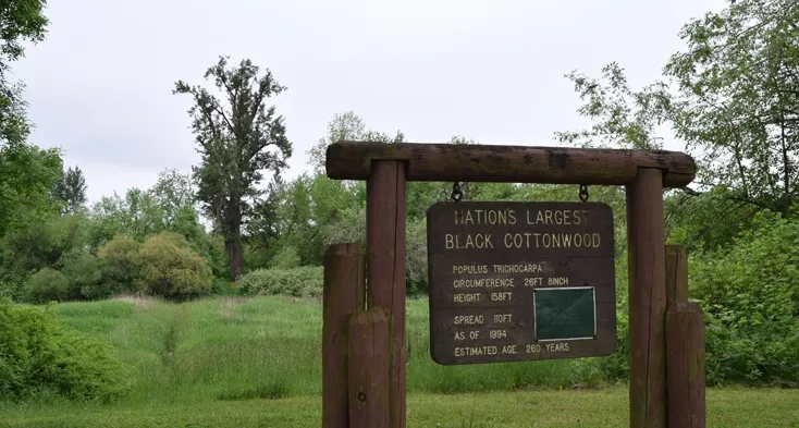
This 270-year old tree is more than 28 feet in circumference, and stands more than 155 feet tall.
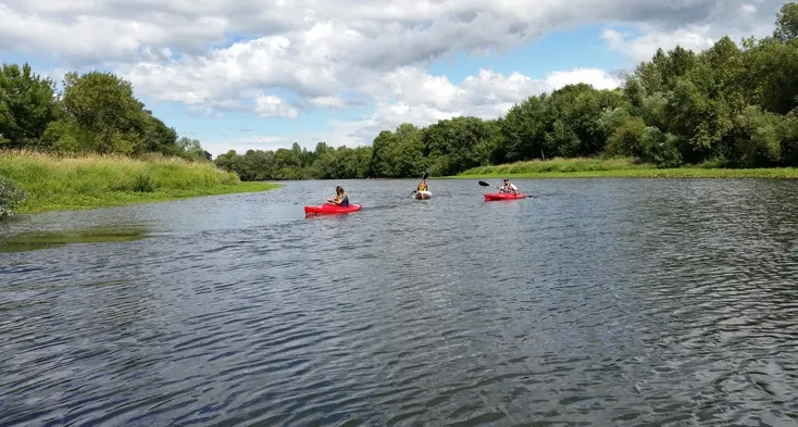
Two trails from the Filbert Grove Day-use Area lead to a beach with a gravel bar popular for launching kayaks.
Boaters: check ahead for obstructions on the Oregon State Marine Board's Reported Obstructions and Alerts page. Flooding may occur during heavy rainstorms in winter and spring.
Check the park notice or call the park o
Setting
Landscape & setting
The park’s 1,300 acres include woodland, wetland, rolling meadows and working farmland.
Things to do
Things to do
Visitors also have a chance to explore almost 15 miles of trails on foot or horseback. The nation’s largest black cottonwood sits on the shores of Mission Lake.
Park Trails 5 miles of bike paths 6 miles of horse trails 2 ½ mile self-guided education trail 1 mile jogging loop Note: Trails flood during heavy rainstorms in winter and spring.
Check this page for closures. Water Play Anglers will enjoy fishing for bluegill, crappie, carp and largemouth bass in Mission and Goose lakes.
Fishing at Goose Lake requires some trailblazing, and the undeveloped trail can flood in the winter and spring (watercraft walk-in only).
A permit is required for camping along the Willamette River Water Trail ; call or visit the park office to obtain one.
Know Before You Go Do not swim, float, paddle or boat without a life jacket. Wearing a life jacket, and making sure it fits properly , saves lives.
Background
History & notes
The rise and fall of Willamette Mission The park commemorates the site of Willamette Mission, which served as the first Methodist mission on the west coast and as a boarding school for Native American youth from 1834 until 1841. Established by Québec-born Rev. Jason Lee , the mission marked one of the first Euro-American communities in the Willamette Valley. Lee and his team of four men arrived Oct. 6, 1834. Racing the coming winter, they built a log Mission House to serve as a school, chapel, kitchen and living quarters. It became the center of missionary life. From 1835-1841, the mission grew to include a chapel, hospital, log cabin homes, blacksmith shop, granary and 30-acre farm. The complex became known across the U.S. as “Wilamet” Station at Mission Bottom and served for a time as the headquarters for satellite missions across the Pacific Northwest. The Methodist Missionary Society in New York sent several reinforcements to expand the community. These newcomers included a doctor, blacksmith, and teachers -- including the woman who would become Lee’s wife, Anna Maria Pittman . But from the outset, Lee faced logistical and cultural challenges in establishing his boarding school and converting the Native people. While some Native Americans did convert to Christianity, others struggled to fit this new religion into their existing worldviews. Additionally, foreign illnesses were decimating native populations. Frequent floods at Mission Bottom pushed Lee to move the headquarters in 1841 to Chemeketa Plain. He reopened the boarding school and named it the Indian Manual Training School, which would become Willamette University. Families traveling the Applegate and Oregon Trail continued to use the abandoned mission buildings until a catastrophic flood in 1861 washed them away. The state acquired the property through donation in 1979 and opened it to the public as a state park in honor of Lee’s contribution to Oregon’s history. Though the mission itself was transient, Lee’s legacy endured — both as a catalyst that helped to put Salem on the map as the state’s political capital, and as a reminder of the upheaval in the lives of the Native Americans who first called this area home.
Today
Weather
Forecast is advisory — confirm park hours before you go.
Plan your visit
Nearby
More parks in Salem
Data quality
Sources
Confidence checks: coordinates · website · image · hours · amenities (and last verified when known).
Confidence score
85/ 100
Oregon State Parks
- official website
- coordinates
- amenities
- hours
- image
- last verified
Confirm hours on the official page before visiting.